Our Data Insights with Tableau
In this project, scholars demonstrate their proficiency in using one of the leading data visualization tools in the industry: Tableau. Using existing datasets, scholars transform raw data into compelling, easy-to-understand visual narratives. Scholars learn to clean, organize, and analyze their datasets, identifying key insights and trends, as well as explore various chart types, filters, and interactive elements to make their dashboards both informative and engaging.
NEW FROM NVOLVE SCHOLARS
Fall 2025
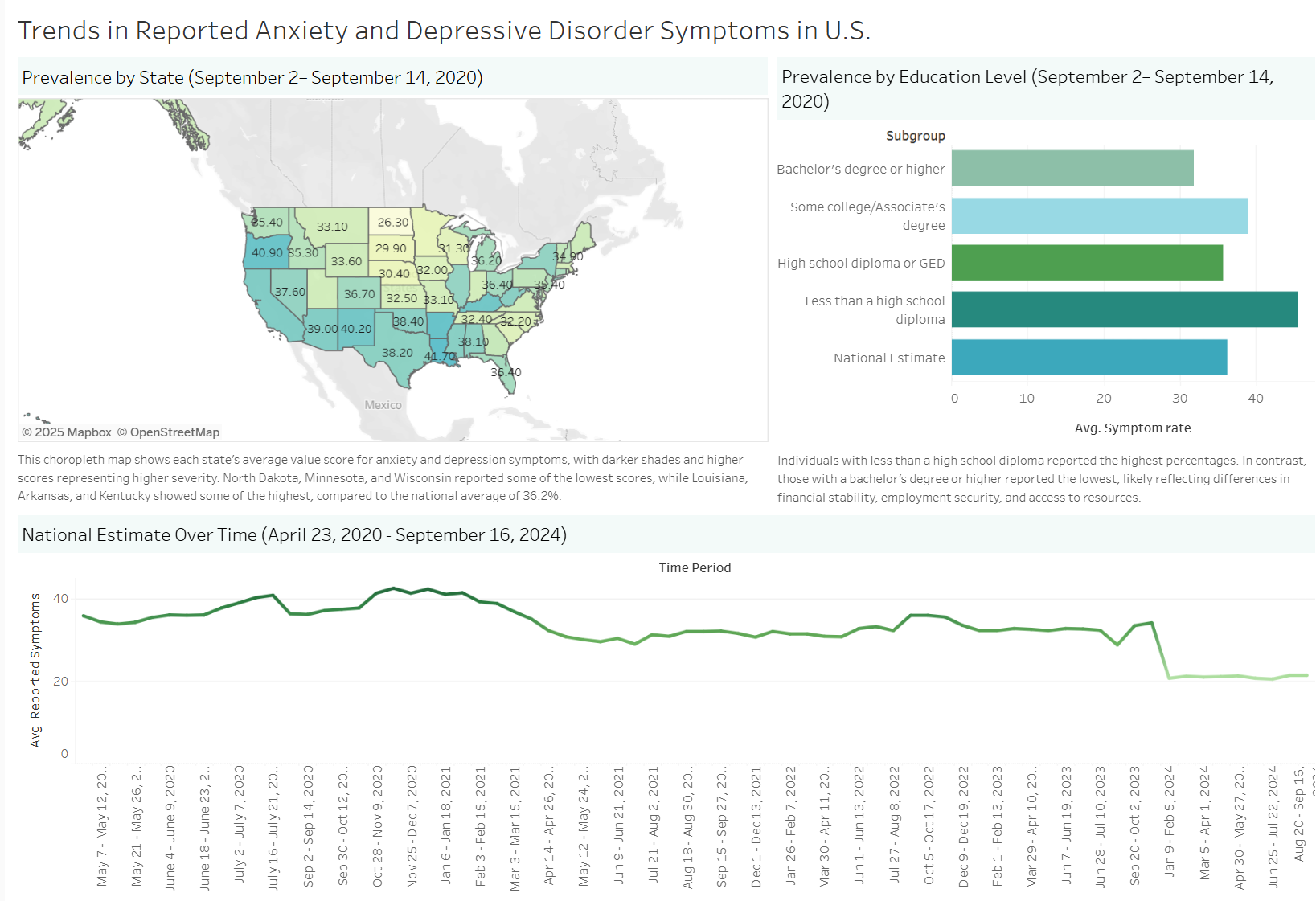
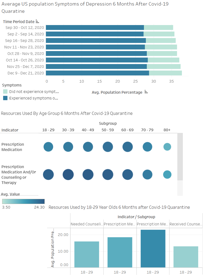
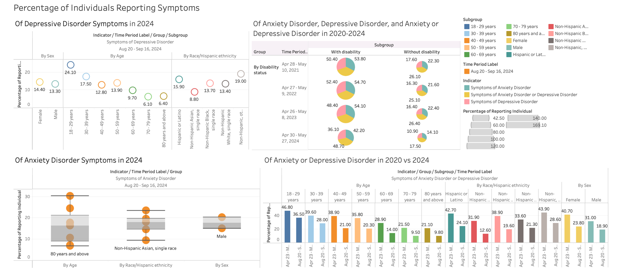
This project analyzed anxiety and depression indicators from the U.S. Census Bureau’s Household Pulse Survey to understand mental health trends during the COVID-19 pandemic. Using Tableau, the team visualized differences by state, education level, and time, showing higher symptom severity in 2020 and among groups with lower educational attainment. Collaboration, data visualization, and effective public health storytelling were key takeaways. Read more…
Fall 2025
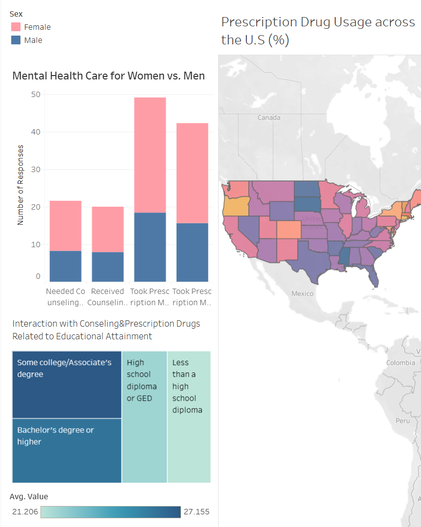
This project analyzed U.S. Census Bureau Household Pulse Survey data from 2020–2022 to examine mental health care access, usage, and unmet needs during the COVID-19 pandemic. Using Tableau, the team created multiple visualizations to highlight trends across age, gender, education level, and region, revealing higher symptom severity among young adults, greater care utilization among women, and notable regional differences in prescription use. Key takeaways included building Tableau proficiency, connecting data to public health literature, and strengthening skills in translating complex datasets into clear, evidence-based visual narratives. Read more…
Fall 2025
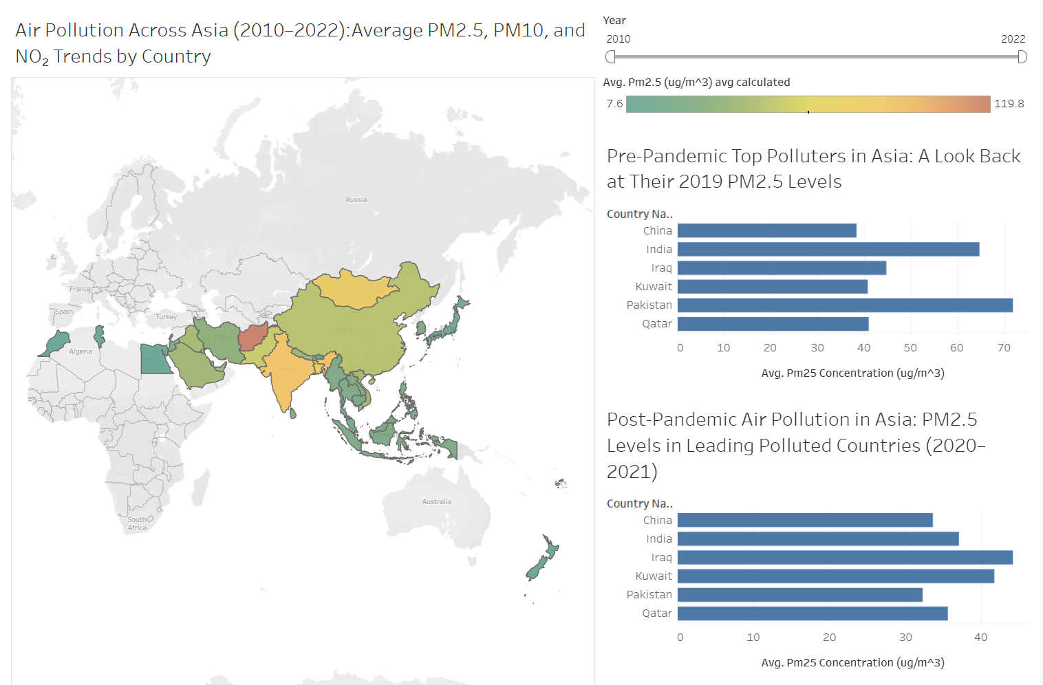
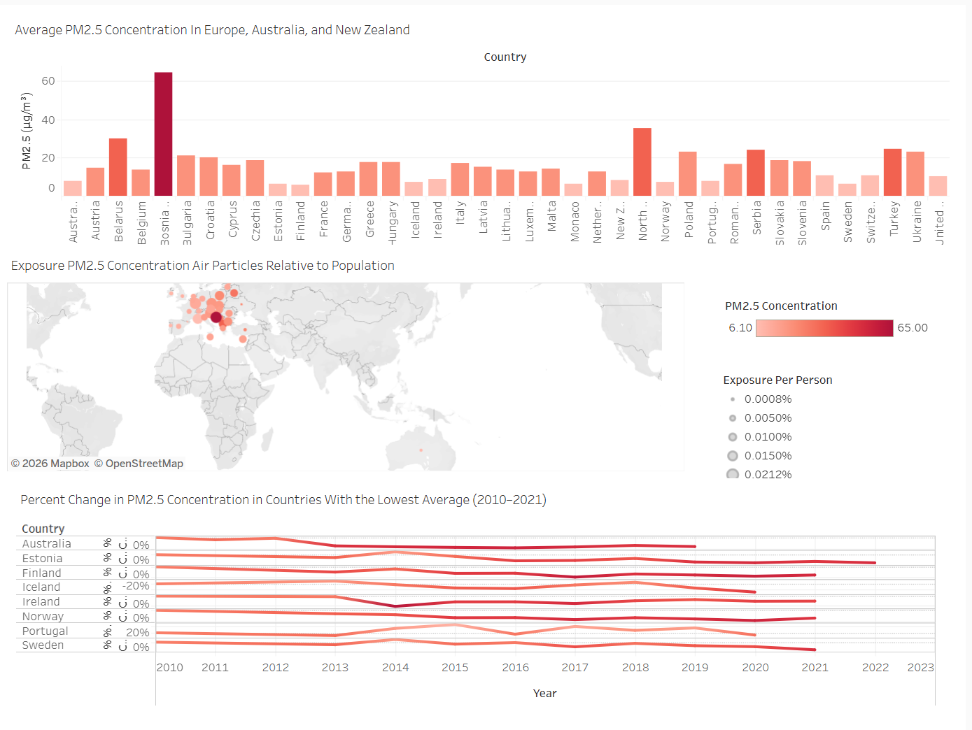
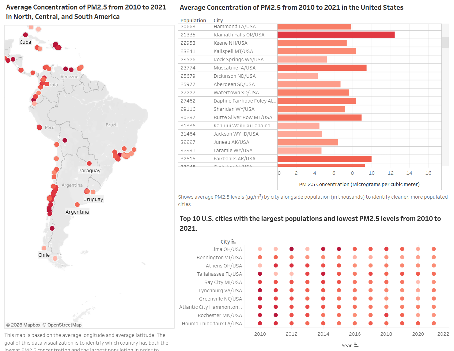
This project analyzed World Health Organization air quality data from 2010–2022 to compare global pollution trends across the Americas, Europe/Australia/New Zealand, and Asia using PM2.5, PM10, PM1.0, and NO₂ indicators. Through continent-based visualizations and interactive dashboards, we identified regional patterns, cleanest cities and countries, and post-pandemic shifts in air quality, strengthening our skills in comparative analysis, data visualization, and communicating environmental insights through Tableau. Read more…
Fall 2025
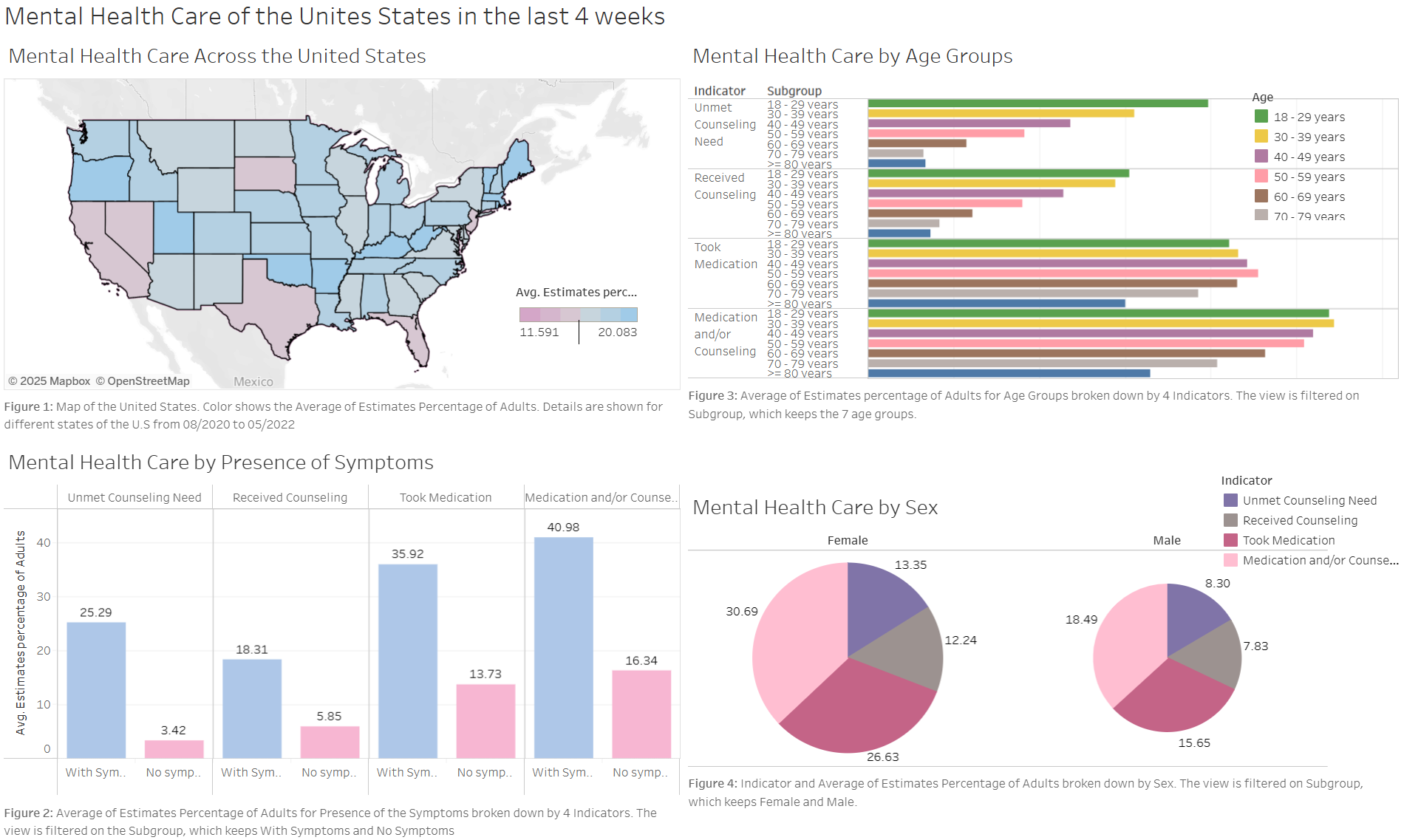
This project examined differences in mental health care access across the United States using CDC Household Pulse Survey data from 2020–2022. Through Tableau maps, bar charts, and tables, the team highlighted regional disparities, higher unmet counseling needs among young adults, greater treatment engagement among women, and variation by symptom status. Key takeaways included developing data visualization skills, applying public health context to real-world data, and strengthening collaboration across interdisciplinary backgrounds. Read more…
Fall 2025
This project analyzed the National Walkability Index using Excel, Power Query, and Tableau to explore how walkability varies across U.S. regions. Our findings showed higher walkability in dense urban areas, lower scores in rural and suburban regions, and significant variation within states, while strengthening our skills in data cleaning, visualization, teamwork, and data storytelling. Read more…
Previous Projects
Spring 2025
This project focused on how obesity rates in the U.S. have shifted over time across different demographic groups, including age, gender, and income. By analyzing national health data from 2011 to 2023, the team identified consistent disparities, with certain populations experiencing higher obesity rates than others. The findings emphasized how factors like age and income level continue to play a significant role in public health outcomes. Read more…
Spring 2025
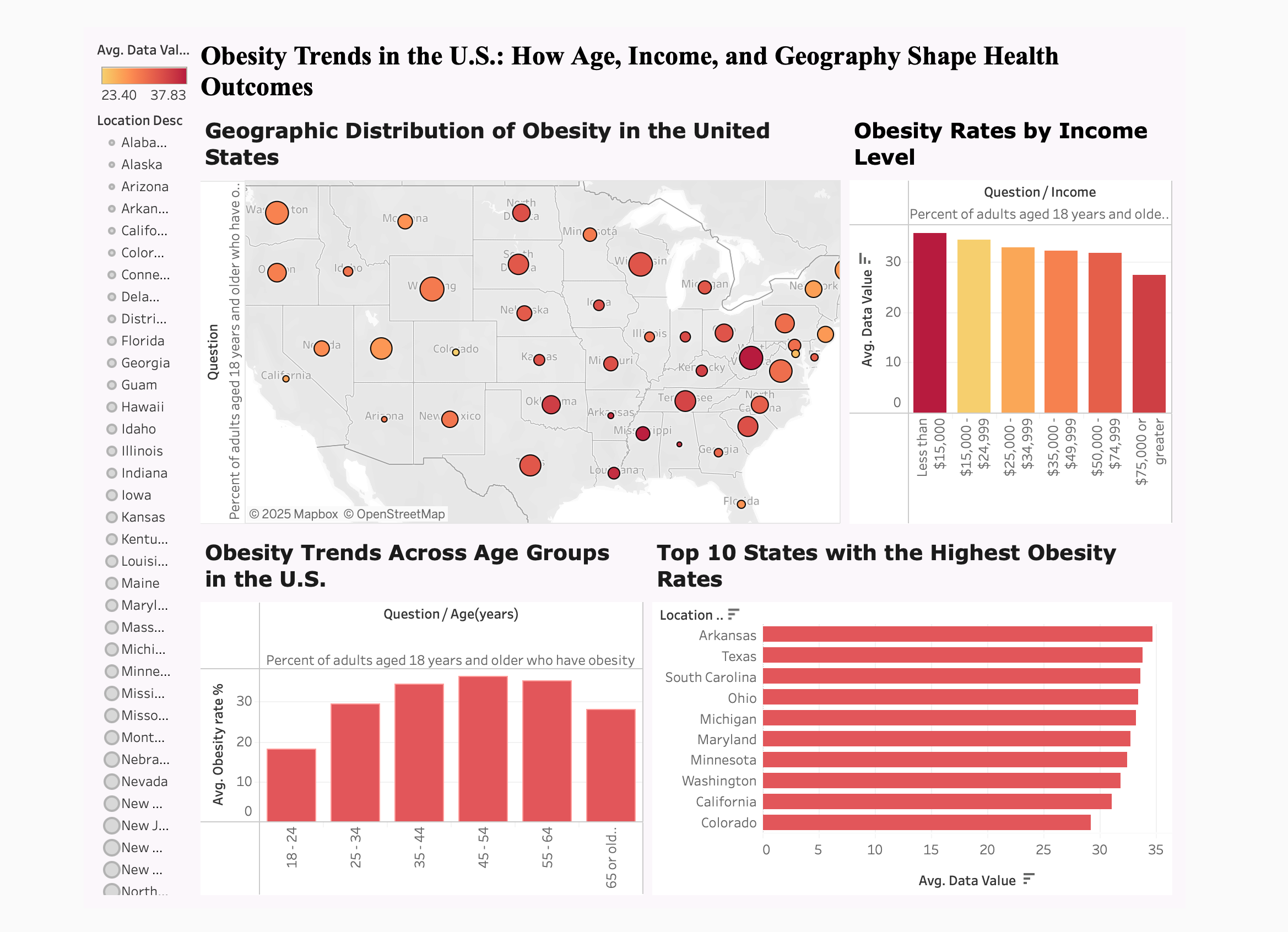
This project examined national obesity trends using data from the Behavioral Risk Factor Surveillance System, focusing on changes over time and differences across age groups and states. Through interactive Tableau visualizations, the team highlighted how obesity rates have steadily increased nationwide from 2011 to 2023, with middle-aged adults showing the highest prevalence. The analysis also revealed significant geographic disparities, underscoring the importance of targeted, state-level public health strategies. Read more…
Spring 2025
This project examined trends in obesity, physical activity, and nutrition using data from the Behavioral Risk Factor Surveillance System collected between 2011 and 2023. By analyzing state-level differences and demographic variables such as age, income, education, and gender, the team uncovered important patterns in public health. Key findings included consistently rising obesity rates nationwide, alongside a notable increase in muscle-strengthening activity after 2019. Read more…
Spring 2025
This analysis examined mental health trends in the U.S. using CDC data on reported anxiety and depression symptoms. Focused on changes over time and across demographics such as age, gender, and geography, the findings highlighted a sharp increase in symptoms during the COVID-19 pandemic, particularly between 2020 and 2021. Young adults aged 18–24 consistently showed the highest levels of reported symptoms. The project emphasized growing mental health concerns and the value of breaking down data to uncover key disparities. Read more…
Spring 2024
Greenhouse emissions are gases released into the atmosphere, like carbon dioxide (CO2), methane (CH4), and nitrous oxide (N2O), which trap heat from the sun and warm the Earth's surface. This effect is essential for keeping the Earth warm enough to support life. The purpose for this project was to show the variations and contributions of emissions overtime. Summer was the season with the highest number of emissions contributing to about 2000 more. Read more…
Spring 2024
Studies have shown that populations that are exposed to higher levels of air pollution, particularly PM2.5 and nitrogen oxides, were associated with an increased risk of long COVID symptoms as well as COVID-19 mortality. However, because human activities drastically decreased across the globe during COVID-19 lockdowns, air pollution significantly decreased (including PM2.5 and NO2 levels). Read more…
Spring 2024
Our analysis uncovered trends and patterns among various races and ethnicities over time, revealing that white individuals have the highest number of COVID-19 cases. Read more…
Spring 2024
March consistently shows the highest percent increase in COVID-19 cases compared to the previous month. Read more…
Spring 2024
Analyzing COVID-19's impact on Maryland's diverse population reveals disparities and trends within the state's communities. Read more…
Spring 2024
We discovered the underlying patterns, trends, and pivotal attributes defining electric vehicles. Read more…
Spring 2024
Through meticulous analysis, we revealed crucial trends and disparities, shedding light on the pandemic's unique impact on different communities. Our findings uncovered how COVID-19 has disproportionately affected certain racial and ethnic groups, highlighting systemic inequalities and health vulnerabilities. This comprehensive examination not only enhances our understanding of the pandemic's broader effects but also provides valuable insights for public health strategies, policy-making, and future research. Read more…
Fall 2024
Electric vehicle trends were analyzed using Tableau, focusing on car popularity, brand distribution by state, and Tesla's growth over time. Overcoming early challenges with scheduling and data visualization tools, the team honed their Tableau skills, developed meaningful insights, and learned to ask the right questions for data analysis. Read more…
Fall 2023
Delving into the health indicators of Wisconsin and Maryland, these visualizations shed light on disparities in chronic disease outcomes and prompted reflections on the potential influence of demographics and environmental factors. I hypothesized that Black minority groups would have a lower amount of vegetables and fruit consumed because of the likelihood of food deserts in their neighborhood and the built environment. Read more…
Fall 2023
Meteorites are space rocks that fall to the earth’s surface. Our analysis of the data focused on the size of the meteorites, and where they have fallen in their various quantities. We focused on looking at where meteorites are mostly falling in the United States and saw that the most meteorite landings are along the New Mexico and Texas border. It was also very interesting to see which meteorites the heaviest and largest meteorites, Xifu and Al Hagggouria, weighed three million grams. Read more…
Fall 2023
For our project, we looked at the 2020-2021 rates of binge drinking, heavy drinking, and total alcohol consumption per capita in different states and compared it to the rate of liver disease mortality in those states. To see if there was any correlation between the groups, we created a bar graph to visualize liver disease mortality rates in all 50 states, color coding the top 10 states in a gradient red, the lowest 10 states in gradient blue, and the middle 30 states in a gradient purple. Read more…
Fall 2023
We analyzed the mortality rates of total cardiovascular disease among different race and ethnic groups in Maryland. Read more…
Fall 2023
Preventive dental care before pregnancy is hugely important. Since 2016, prenatal dental care has significantly declined. Its prevalence varies among states in the US, with many Northern states exhibiting higher rates compared to the South. Interestingly, White and non-Hispanic populations exhibited a notably higher rate of prenatal preventive care. Read more…
Fall 2025
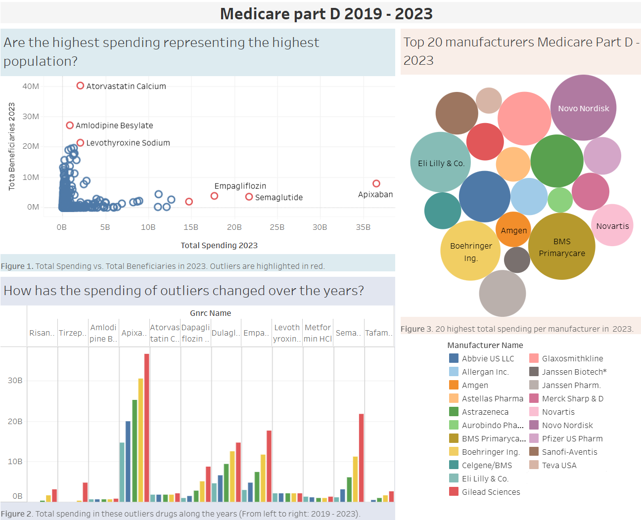
This project examined Medicare Part D prescription drug trends from 2019 to 2023 to better understand patterns in drug use, spending, and beneficiary coverage. Using Tableau, the team created visualizations to explore relationships between prescription volume, costs, and efficiency, highlighting how certain drugs and manufacturers drive overall spending. Key takeaways included collaborative problem-solving, strengthened data visualization skills, and improved ability to communicate healthcare insights through clear, data-driven storytelling. Read more…
Fall 2023
By analyzing meteorites’ classification, mass, and landed location, we found that the number of meteorites that fell each year were most significant between 1970 to 2011. Among the five main types of meteorites, chondrites were the most abundant. The regions where most meteorites were found include Antarctica, the United States, Australia, North Africa and the Southeastern Gulf area near Oman. Read more…
Fall 2023
We scoped out the correlation between chronic disease indicators with life expectancy in which we observed the ten highest and ten lowest life expectancy states. Read more…
Fall 2025
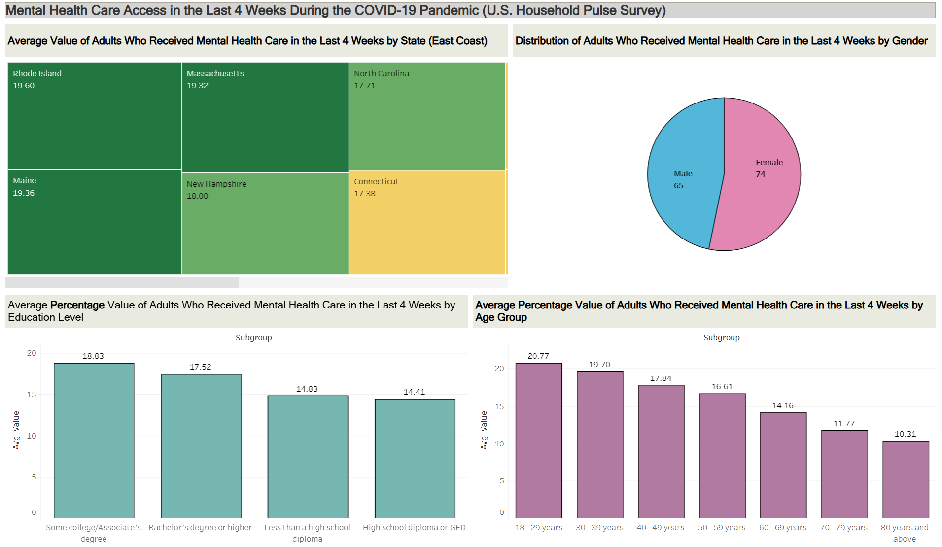
This project used Tableau to visualize mental health data from the CDC’s Household Pulse Survey, focusing on access to care and survey participation during the COVID-19 pandemic. By examining differences across demographics such as age, gender, education level, and region, the dashboards highlighted patterns in who received mental health care and who was represented in the data. Key takeaways included collaborative analysis, improved dashboard design skills, and a deeper understanding of how demographic factors shape mental health data and interpretation. Read more…
Fall 2025
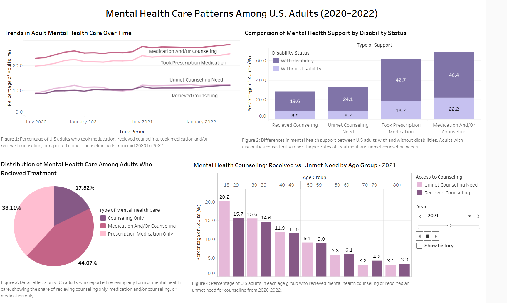
This project analyzed U.S. mental health care trends using Census Household Pulse Survey data, visualizing differences in access and unmet needs by age, gender, disability status, education level, and time. Through data cleaning, analysis, and storytelling with Python, Excel, and Tableau, we built clear visual insights and strengthened our skills in data visualization, collaboration, and communicating complex social issues through data. Read more…
Fall 2024
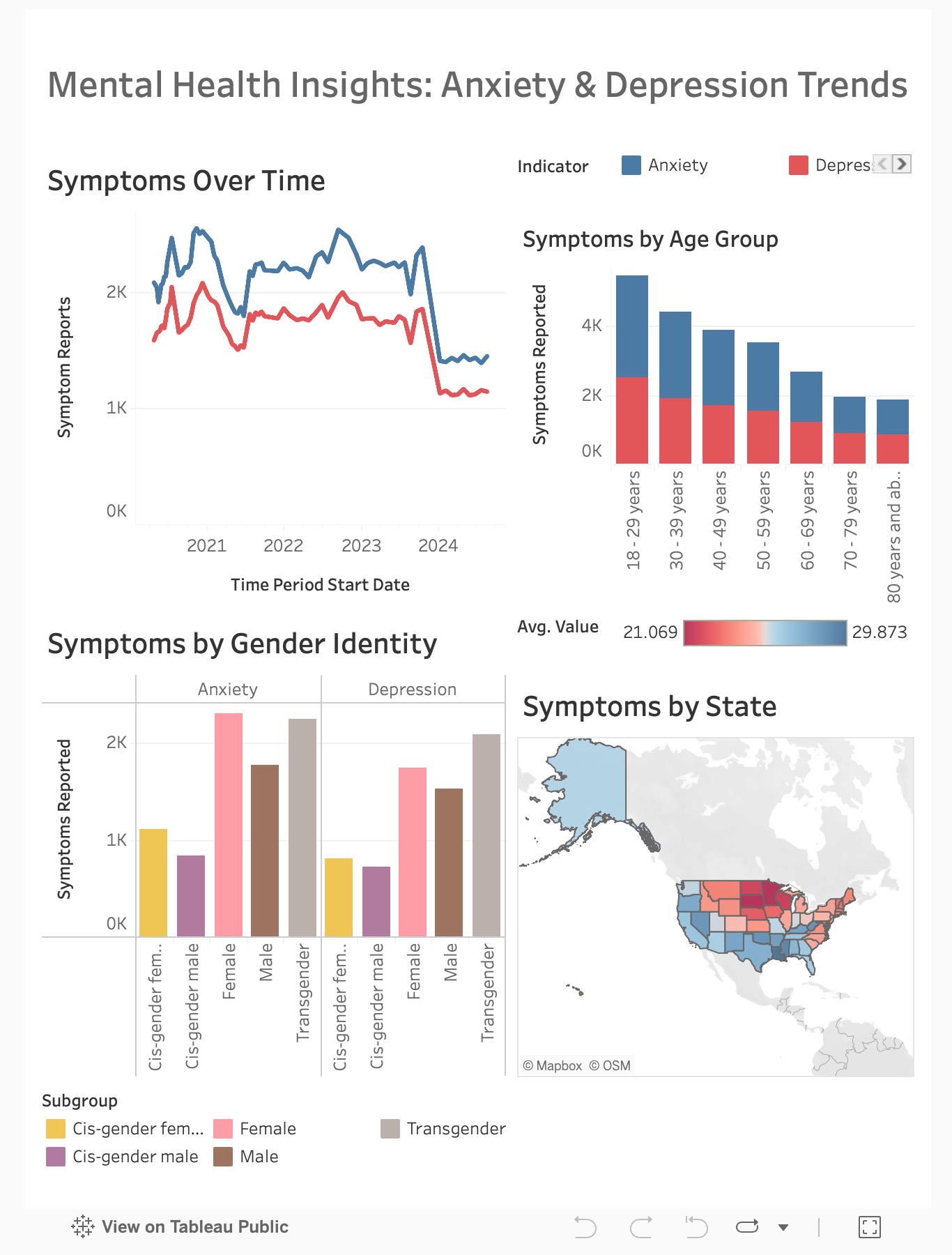
Analyzed mental health data using Tableau, highlighting trends in anxiety and depression symptoms by age, sex, race/ethnicity, state, and disability status. Key findings showed declining symptoms over time, higher rates among females and younger individuals, and state-wise variations. The experience boosted data visualization skills and collaboration. Read more…
Fall 2024
Explored mental health trends using data on anxiety and depression symptoms reported over seven days, focusing on demographics like age and region. After switching datasets mid-semester to improve storytelling, the team successfully visualized insights with clarity. The experience highlighted the importance of thoughtful dataset selection, collaborative analysis, and effective time management. Read more…
Fall 2024
With the air pollution's effects on health in New York City, the graphs focus on pollutants like fine particulate matter smaller than 2.5 micrometers and their impact on respiratory outcomes. Using Tableau, the team visualized trends, revealing Manhattan's higher pollution levels and Staten Island's cleaner air. Collaboration, effective storytelling, and enhanced technical skills were key takeaways. Read more…
Fall 2024
Using mental health data to uncover trends in anxiety and depression symptoms across various demographics. Key findings included higher symptoms among younger adults, bisexual individuals, females, transgender individuals, and Hispanic/Latino populations. Education level and geography also influenced symptom rates. The project highlighted the value of thorough data preparation, effective visualization, and collaboration. Read more…
Spring 2023
Ecological footprint: It is a method developed by the Global Footprint Network to measure human demand on natural resources. In other words, the quantity of nature it takes to support people and their economies.
EcologicalDeficit: Countries use more natural resources (Ecological Footprint) than their ecosystems can generate (biocapacity). They are running an “ecological deficit”.
Ecological reserve: When a country’s biocapacity exceeds its population’s ecological footprint, it has an ecological reserve. Read more…
Spring 2023
This experiment aimed to see how the number of COVID-19 cases varied by race between 2020 and 2022. This investigation was limited to Maryland, United States. The data was collected by the state of Maryland and made available to the public. The data set comprised information from White, African American, Hispanic, Asian, and Other people. Read more…
FALL 2022
The goal of this project was to determine how the number of COVID-19 cases differed by race over time between 2020-2022. This analysis focused on Maryland, United States, and disregarded any other geographical locations. The data was collected by the state of Maryland and posted for public use. The data set included data from White, African American, Hispanic, Asian, Other, and “Not Available” races. Read more…
FALL 2022
In March 2020, the World Health Organization declared COVID-19, the disease caused bySARS-CoV-2, a pandemic (‘WHO Director-General's’, 2022). Our goal is to communicate whether the prevalence of mental health issues in five states in the United States with the lowest mental health is correlated with the COVID-19 pandemic. Read more…
SPRING 2022
The COVID pandemic has affected all aspects of our society, including flight availability. Through the COVID pandemic, states have made their COVID policies to decrease the spread of the disease. Some states like Texas and Florida have enforced minimum restrictions, whereas states like New York and California have enforced strict COVID mandates. Read more…
Spring 2023
Our team has analyzed the SHIP Life Expectancy 2015-2017 data set from the Maryland Department of Health. The main objective was to study how life expectancy has changed and varies across diverse ethnic groups and jurisdictions. To achieve this, we utilized various charts and visualizations in Tableau. Read more…
Spring 2023
Our project focused on the life expectancy data of Maryland from 2007-2017. This dataset came from the from the Maryland Department of Health. When we got the data we didn’t expect to have as many gaps and missing data as it did. Our data was missing data for certain demographics such as White Hispanic, Native American, and Asian populations. This is very significant data as White Hispanic make up 18.7%; of Maryland's population and Asians alone makes up 6%, and Native American is .7%. Read more…
FALL 2022
Air Pollution is caused by various contaminants such as NO2 (ug/m3), PM10 (ug/m3), and PM2.5 (ug/m3) present in the atmosphere. These contaminants are very harmful to human health and so precautions are required. The World Health Organization (WHO) offers global guidelines for important pollutants that risk human health and the environment. In this project, we aim to create two dashboards using Tableau to visualize air pollution over the world by addressing our individual questions. The data that we used is from the WHO Air Quality Database. Read more…
FALL 2022
The COVID-19 pandemic impacted people all across the globe. Most developed countries imposed social distancing and quarantines during the peak of the pandemic. This resulted in behavioral changes such as working from home, avoiding traveling, social distancing, and closure of businesses related to entertainment. Read more…
SPRING 2022
Many industries and businesses have been affected by the Covid-19 pandemic. One of the hardest-hit industries in the early months of the pandemic was Airlines. This project analyses different airlines' flight data between 2019-2021 to study the effect of the pandemic among the United States airlines. Read more…


